"THIS TOOL REALLY EMPOWERS THEM. THERE’S BETTER PLANNING AND MORE EFFICIENCY IN WHAT WE DO, DAY IN AND DAY OUT."
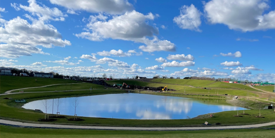
The Kerdiffstown landfill remediation project in Kildare sees the transformation of a 30-hectare former landfill into a new public park with all-weather sports pitches, playground, and walking paths for local residents. To manually survey a site like Kerdiffstown could have taken two weeks for a survey engineer - but surveying with a drone and processing the data with Trimble Stratus shortened that process to approximately one day.
Wills Bros, a family-run contractor based in Ireland and the UK, has long embraced construction technology advancements such as 3D surveying and machine control. Their diverse client base includes government bodies, local authorities, airports, port and rail authorities, blue chip companies, and national road authorities.They began using Trimble Stratus back in 2020 and it is now widely used across the entire company.
Appointed by Kildare County Council, Wills Bros’ primary responsibilities for Kerdiffstown include the installation of an engineered capping system across the site, and the installation of new environmental management and control systems to ultimately deliver the multi-use public park. These are containment technologies that form a barrier between the waste source area and the ground surface to minimise people’s and the environment’s exposure to the contaminated area.
The Kerdiffstown landfill had long been a hazard in the local community from air pollution to even catching fire! The plan was to cap the waste on this site with liners and geotextiles to develop the recreational area, providing the local community with public land space and removing the hazard. Wills Bros’ first task was to demolish several concrete buildings on the site that were part of a recycling plant and transform the landfill into a uniform shape. An interesting aspect of their approach was the integration of drone surveys and Trimble Stratus into the project, as shared by director Jonathan Wills:.
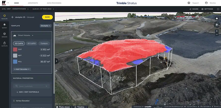
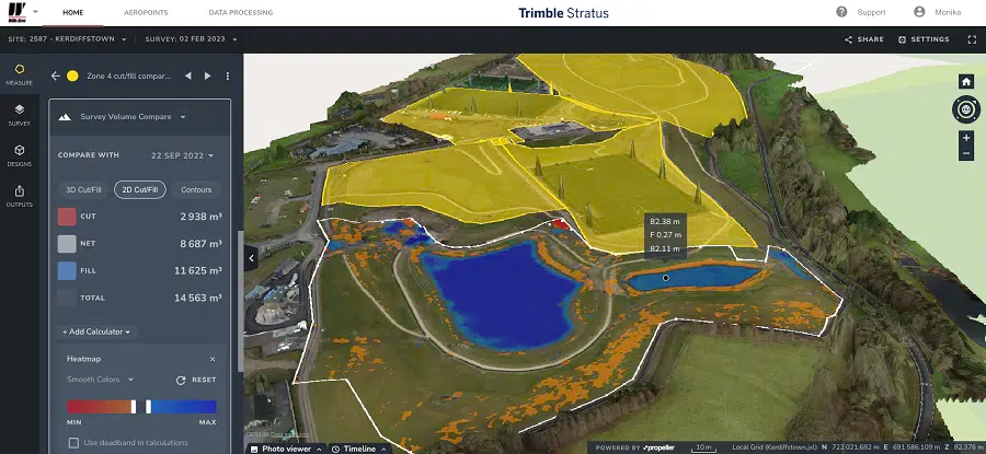
“We began using it on the project to capture weekly project photos for the client and to keep track of the quantities of waste materials we had to move around the site, as we began reprofiling the landfill. We created a model of the existing landfill and then we were able to generate a cut/fill balance against the final project design. We were then able to track that regularly and see how we were progressing on the project.”
Additionally, it proved to be highly advantageous for Wills Bros during their regular progress meetings with the client. The use of 3D maps and photos enabled them to identify on-site issues or challenges, facilitating discussions and solution-seeking within their office. This eliminated the need for team members to physically visit the potentially hazardous site, ensuring enhanced safety and efficiency.
Some early challenges on the project centered on implementing the project design correctly. Once reprofiling and shaping the site began, the Wills Bros team discovered that sections of the design needed to be reworked in order to properly install the liners. With the 3D terrain model generated by Trimble Stratus, they were able to create the optimum, uniform design for the project. Also, when balancing the site, Wills Bros had to be careful not to overdig, because doing so could release toxic gas into the air.
“We had to be very careful that we had our material movement down to a very fine balance,” explained Jonathan. “Our surveys in Trimble Stratus were key to keeping that focus. Between the 3D survey and our machine control, we were able to connect it all together to get accurate information.”
Trimble Stratus reduced Wills Bros’ lack of information and data in terms of surveys and 3D models. To manually survey a site like the Kerdiffstown project could have taken two weeks for a survey engineer. But by surveying the site with a drone and processing the data with Trimble Stratus, surveying was shortened to approximately one day. Now their engineers can focus on making sure their work is of the highest quality with no rework.
“Having access to that real time information makes us as a business more efficient, more agile and our engineers can make better decisions, quicker. This tool really empowers them. There’s better planning and more efficiency in what we do, day in and day out. That in turn gives program certainty to our clients and to us. It also reduces the risks facing our teams in the field, as they don’t have to walk the site as often.”
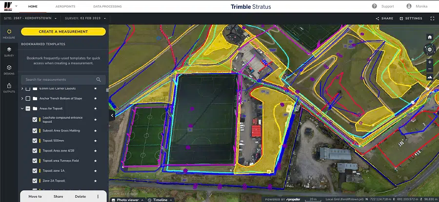
Wills Bros also gives their client access to the site maps within Trimble Stratus, which helps to eliminate any difference of opinion and streamlines their monthly meetings, ensuring smoother and more efficient discussions. With the timelapse feature they can show their client month to month what has changed on site.
“Commercially, when you’re sitting down with your client you have near real time, accurate information to use in the discussion. The 3D model speaks for itself. It’s all transparent and open, and helps with any commercial discussions. It’s very easy for our clients to follow, aids in our collaboration with them, and builds complete trust. Putting the model and video of the site up on the screen generates positive conversations among our team and our clients, which leads to productive problem solving.”
Since its adoption four years ago, Trimble Stratus is now well embedded at Wills Bros. Over half of the company is using the platform, making it an essential collaboration tool. Users are spread across several departments, and each group uses the site data and maps for different purposes:
Jonathan Wills also shared that the environmental and safety departments use it to ensure compliance and to spot any hazards that need to be addressed.
“There’s not one department across Wills Bros that is not using Trimble Stratus to some extent. It’s a great information tool for our business to inform each other about the ongoing work. The videos and maps speak volumes and different departments take different information from those …and accurate information is key to any business.
I’ve never seen any technology be adopted across the company this quickly, which speaks to the quality of the product and its ease of use. The gains have been overwhelming. Everyone wants a job within budget, completed ahead of programme and with a good working culture, and Trimble Stratus has given us that.”